


Page 33 - Froghall Drive Our Story
P. 33
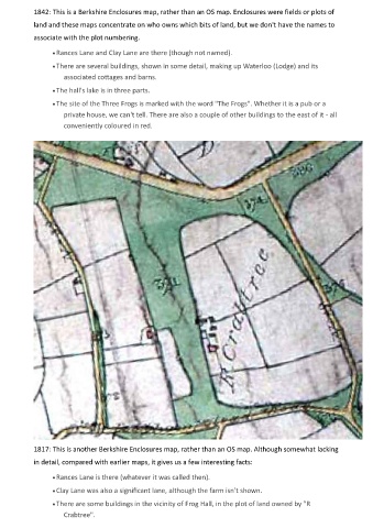
1842: This is a Berkshire Enclosures map, rather than an OS map. Enclosures were fields or plots of
            land and these maps concentrate on who owns which bits of land, but we don't have the names to

            associate with the plot numbering.

                  • Rances Lane and Clay Lane are there (though not named).
                  • There are several buildings, shown in some detail, making up Waterloo (Lodge) and its

                     associated cottages and barns.
                  • The hall's lake is in three parts.

                  • The site of the Three Frogs is marked with the word "The Frogs". Whether it is a pub or a
                     private house, we can't tell. There are also a couple of other buildings to the east of it - all
                     conveniently coloured in red.


            1817: This is another Berkshire Enclosures map, rather than an OS map. Although somewhat lacking
            in detail, compared with earlier maps, it gives us a few interesting facts:

                  • Rances Lane is there (whatever it was called then).

                  • Clay Lane was also a significant lane, although the farm isn't shown.

                  • There are some buildings in the vicinity of Frog Hall, in the plot of land owned by "R
                     Crabtree".

